Rymer’s Lane
A small group of local stakeholders interested in ensuring the best functioning of Rymer’s Lane when the LTNs start met recently to discuss possible contingencies.
On the map below is the section of roadway in question (Image 1). The new double-yellow lines are indicated, along with public parking (off-street), an area of loading required by Flo’s and Isis Midwives, and the March 2021 traffic filter associated with the Florence Park Low-Traffic Neighbourhood.
Image 1
Image 2
This Google Streetview image is taken just south of Flo’s (Image 2). This is the road used regularly by parents to drop their children by car at St. Frideswide C of E primary school (formerly St Gregory the Great RC primary school). You can see their proximity in Image 3.
Image 3

Here is the volume of cars doing the school run (Image 4). This is February 2019 but the same footage has been shot here in September 2020.
Image 4
In March 2021, these cars will face a traffic filter (indicated in Image 1 and in this map of the overall LTN scheme). Parents of children needing to be walked to the school gate will be tempted to park opposite the double-yellow line in Image 1. This is currently used for car storage. It is now much fuller than indicated in Image 2, possibly due to the controlled parking zone (CPZ) that has been put in place just north of here, where Rymers Lane turns into Cricket Road (Image 3).
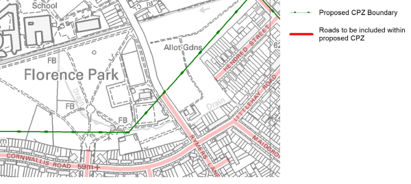
In 2021 or 2022, the Florence Park area area will be due for a consultation on a CPZ. However, this doesn’t currently envisage the section of Rymers Lane outside Flo’s / Flo’s Nursery / Isis Midwives (Image 5). The county should consider now what is the best course of action for this road. Our preference is a double-yellow line with set-aside loading spaces for Flo’s deliveries and two parking bays for the community midwives.
Without the double-yellows on both sides, parents on the school run would be rightly interested in parking along this road and walking their child(ren) into school (six-minutes journey in Image 3). One can imagine a line of queueing parents waiting for a slot to become available. We know from the academic work of Shoup (below) and others that even a fractional probability of a parking space becoming available induces queueing.
Very little would be lost by eliminating parking on this section of Rymers Lane (apart from 2 dedicated midwives’ spots and a loading bay). There would still be plenty of parking in the newly-expanded parking lot built by the city in the park a couple years ago (Image 1).
Image 5 (Cutaway from this map (pdf))
But the parking lot needs attention. Given that it will soon be surrounded by CPZs — and with the would-be double-yellow lines along this section of Rymers Lane, one can imagine it will be overrun with a combination of car storage and commuter park-and-ride.
One idea is to make one-third of the spaces disabled-only and the rest of them pay-and-display with first two hours free. (And if this alone doesn’t leave sufficient free spaces for visitors to the midwives, then six set-aside spaces for them should be provided.) That seems a necessary but not sufficient step for the overall LTN project. If the city and county’s aspiration is to make Rymer’s Lane a key corridor for active travel (LCWIP, p. 31), then peak-hours usage of the road by motorists must be looked at:
- Parents driving the school run will be keen to use the parking lot.
- This could create the same queue of vehicles as in Image 4, with the added hazard of constant vehicular entry/exit to the park just as hundreds of children are trying to navigate it on foot or wheel.
Options that have been suggested include:
- School-Street Rymers Lane from the Campbell Road junction all the way to Cricket Road. This would allow parents the opportunity to circulate Rymers Lane – Campbell Road – Florence Park Road. The down side is that this would still wreck part of the Rymers Lane active travel corridor.
- “School Street” the entirety of Rymers Lane, from Between Towns Road to St Greg’s. Parents could park at Sainsburys / Templars Sq. This is a 10-minute walk to Greg’s. A walking bus could also be organised starting from this location so that some parents could drive on from here.
- Introduce a “point closure” to Rymers Lane between the Templars Sq loading-bay entrance and the junction with Campbell Road. (A point closure, also called a “filter”, is a piece of street furniture such as a bollard or planter box – or both – that precludes through-traffic by motor vehicles but not cycles, scooters, etc.)
What’s your view? Get in touch.